


Last night, the 53rd Weather Reconnaissance Squadron flew into the eye of Hurricane Erin—and captured imagery of the breathtaking stadium effect.
These missions provide critical data to the NHC to improve forecasts, helping keep communities safe before the storm makes… pic.twitter.com/RpAs7yMDRf
— Hurricane Hunters (@53rdWRS) August 16, 2025
On August 15, 2025, the 53rd Weather Reconnaissance Squadron, otherwise known as the “Hurricane Hunters,” prepared to take off from their forward base in St. Croix. Their mission? Fly their aircraft straight into Hurricane Erin, all in an effort to discover why it intensified at such a historic rate—and in such a short time.
Formed on August 11, Erin is the fifth storm of the 2025 Atlantic season, and by August 15, it had reached hurricane status during its approach toward the Lesser Antilles. The next day, it had already strengthened into a Category 5 hurricane, with maximum sustained winds reaching up to 160 mph. These grim statistics have only been echoed by satellite footage, captured by the National Oceanic and Atmospheric Administration (NOAA) and NASA’s GOES-19 weather satellite, originally launched in June 2024. One GOES-19 video in particular showcases how dramatic a spiral Erin has transformed into, overwhelmed by frequent lightning flashes, violent winds, and bubbling clouds. At the storm’s center is a churning, black hole.
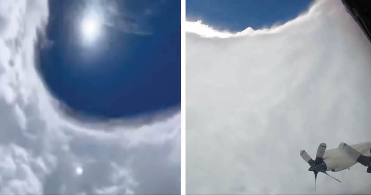
If this isn’t ominous enough, the Hurricane Hunters have now released their footage from their recent outing. Most notably, the team managed to capture the breathtaking “stadium effect,” so named because of the storm’s towering walls of clouds that enshrine the eye like stadium seating. Beyond the swirling clouds is a tranquil sliver of the blue sky, a stark contrast that only enhances Erin’s severity. Eventually, the Hurricane Hunters propel their aircraft deeper into the wall, where the hurricane is at its most powerful. At this point, the video shifts into chaos, the camera pelted by extreme rain and wind that blinds our glimpse into the storm.
Hurricane Erin ultimately moved away from the East Coast without making landfall. But the flight was still time very well spent. “These missions provide critical data to the [National Hurricane Center],” the Hurricane Hunters explain, “to improve forecasts, helping keep communities safe before the storm makes landfall.”
New footage released by the 53rd Weather Reconnaissance Squadron, or “Hurricane Hunters,” reveals the intensity of Hurricane Erin at the eye of the storm.
Unbelievable footage from NOAA’s Hurricane Hunters inside the eye of Hurricane Erin.
Simply incredible. pic.twitter.com/3pTiNI6mpX
— Nahel Belgherze (@WxNB_) August 16, 2025
NASA’s GOES-19 weather satellite has also captured breathtaking footage of the storm, which grew to a Category 5 hurricane in only a day.
Lightning flashes within a powerful, Category 4 Hurricane Erin.
An incredible view this morning from GOES-19. pic.twitter.com/eUy8ko2S6T
— CIRA (@CIRA_CSU) August 16, 2025
Sources: Fly through the eye of Hurricane Erin and see the powerful storm from space (video); Beach Warnings Issued as Hurricane Erin Nears the East Coast; Hurricane Erin tracker: How, when storm will impact NY, NJ; Tropical storm watch issued for North Carolina coast, as Hurricane Erin brings life-threatening rip currents to Outer Banks
Related Articles:
Florida Meteorologist Breaks Down on Live TV While Explaining Hurricane Milton’s Power
Photos of Hurricane Milton Seen From Space Reveal Its Size and Swirling Power
Powerful Photos of Ballet Dancers in Puerto Rico 5 Months After Hurricane Maria


